
FedGeoDay 2022
OPEN GEOSPATIAL ECOSYSTEMS
IN THE FEDERAL GOVERNMENT
Thursday, November 03, 2022 | Washington, D.C.
FedGeoDay 2022
FedGeoDay is THE event devoted to "open geospatial ecosystems" (open source software, open/collaborative mapping, open science challenges, and open engagements) that are used to initiate and grow capabilities across the U.S. federal government. This year we are back in person, and will be bringing together federal program managers, technology leaders, industry partners, NGOs, and many others to share ideas, learn, and network.
Join leaders from the Department of the Interior (DOI), U.S. Geological Survey (USGS), Census Bureau, Department of the Defense, NASA, NGA, USAID, FEMA, DOT, USDA, and many other agencies, as well as top technology firms and NGOs at FedGeoDay and learn how the open geospatial ecosystems can contribute to your work.
#FedGeoDay

@FedGeoDay_US

Use Mentimeter to Continue FedGeoDay Q&A Discussions
Scan the QR Code or go to the FedGeoDay Menti Poll
Live FedGeoDay Menti Poll Results (Embedded Below)


FedGeoDay At-A-Glance
9:00 AM to 12:00 PM
WORKSHOPS
Attend one of the following FedGeoDay Workshops at the American Red Cross for training on leading open geospatial ecosystem technologies and opportunities:
OGC Open Information Ecosystem for Disaster Resilience
The Opportunity Project (TOP) Sprint Adaptability Workshop
Introduction to GeoNode Workshop
Modern Data Dissemination with GeoServer Workshop
Visit the Workshop page for more details. All workshops are FREE and includes LUNCH. To attend a workshop, you must register in addition to the Main Plenary Event.
American Red Cross Building
1730 E Street NW
Washington, DC 20006
12:00 PM to 1:00 PM
REGISTRATION for MAIN EVENT
Department of the Interior (DOI)
Yates Auditorium
1:00 PM to 5:00 PM
MAIN PLENARY EVENT
The Main Plenary Event will include a Keynote Speaker, Panel Discussions, and Lightning Talks from leading experts at the DOI, USGS, DoD, NGA, NASA, USAID, FEMA, DOT, Census, and others, as well as top technology firms and NGOs to learn how open geospatial ecosystems can contribute to your work.

Department of the Interior (DOI)
Visitor Entrance on C Street
1849 C Street NW
Washington, DC 20240
5:30 PM to 7:30 PM
NETWORKING RECEPTION
Enjoy food and beverages at the American Red Cross after the FedGeoDay Plenary Event!
American Red Cross Building
Hall of Service Room
1730 E Street NW
Washington, DC 20006

Keynote Speaker
Frontiers of Open Land Imaging for Data Science
The Sustainable Land Imaging (SLI) Program is a collaboration between the National Aeronautics and Space Administration (NASA) and the Department of the Interior (DOI) United States Geological Survey (USGS) to ensure the continuation of no-cost, high-quality, and global land-imaging measurements compatible with the existing Landsat record dating back to 1972. This talk provides an overview of the development of data science methods at USGS to advance the utility of the Landsat data archive needed to explain, model, and ultimately forecast changes to the Earth's land surface in support of decision-making for societal benefit. The availability of Landsat Analysis Ready Data (ARD) released in 2017 by the USGS over the United States facilitated the development of time-series products as demonstrated through the USGS Land Change Monitoring, Assessment, and Projection (LCMAP) initiative. A long-term objective is to develop a strategic framework for leveraging multiple Earth observing space systems collectively via harmonized observations, together with data science methodology as part of an open global land imaging and science capability.
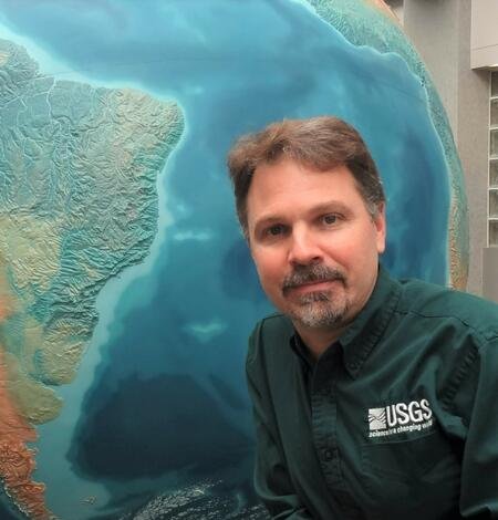
Pete Doucette, Ph.D.
U.S. Geological Survey (USGS)
Dr. Pete Doucette is the Acting Director for the Earth Resources Observation and Science (EROS) Center in Sioux Falls, South Dakota. EROS is part of the U.S. Geological Survey (USGS) in the U.S. Department of the Interior (DOI). The EROS mission is to develop and operate Landsat satellites, and provide land change science data to support our understanding of the changing Earth. Dr. Doucette began his career in geospatial science in 1990, which has included positions with the federal government, a national lab, and the private sector. His past activities include research & development in remote sensing, machine learning, computer vision, and spatial analysis. He holds a Ph.D. in Spatial Information Engineering (UMaine), M.S. in Geomatics (Purdue), and B.S. in Physics (UMaine).

Sponsors
PLATINUM
GOLD

SILVER


BRONZE


PRESS & PUBLICITY


HOSTS